

FACT FILE
Length of walk: 3 miles
Although this is a town walk, a fair part of it lies through water meadows, and there are several stiles, as well as steps. It is also reasonably dog friendly, and dogs are also welcome not only in the museum but also in the town hall and abbey cafés.
This month’s walk by Andrew Swift centres on the ancient hilltop town of Malmesbury. This three-mile walk takes in the abbey, the foundry, the 14th-century courthouse, the 15th-century market cross and the tomb of King Athelstan, grandson of King Alfred
High on a hill in a loop of the River Avon, surrounded by water on three sides, Malmesbury seems almost like a last outpost of the middle ages. When King Alfred established a fortified borough here in 878, its abbey was already over two centuries old, and it would grow to become one of the grandest in the land, with a spire taller than Salisbury Cathedral. The spire collapsed in the late 15th century and soon afterwards the abbey was dissolved by Henry VIII. The town walls went a century later, torn down by decree of parliament after the Civil War. The nave of the abbey survives, though, as one of the most evocative parish churches in the country, and the course of the walls – with views across open country – can still be traced today.
This three-mile walk around the town starts in Station Road long-stay car park (SN16 9JT; ST932875). Few car parks are so attractively sited, with a picnic area alongside the river, and the abbey high on the hill above. As for the station, that closed in 1951, and all that survives of it today is a converted engine shed.
To start the walk, head towards the south end of the car park and turn right across a bridge. On your left are the gardens of Abbey House, largely 16th century, but built on the undercroft of the 13th-century Abbot’s House. When you come to two signposts, bear right to take the step-free route. At the road, cross over to look out from the walls across open country. The strips in the pavement to your left mark the site of the town’s West Gate.
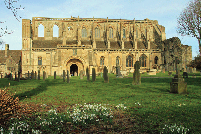
Above: Malmesbury Abbey
Turn right along Abbey Row towards the Triangle – originally Sheepfair. Keep to the left and a few metres further on turn left down Burnivale. The spire dominating the view along this narrow street is all that remains of St Paul’s, Malmesbury’s original parish church, which fell into disuse in the 16th century.
After 250m, when the lane ends, turn right along a bridleway. After crossing a bridge, turn right alongside the river and follow the path as it curves to cross a clapper bridge over a mill leat.
Turn right alongside the river – although not before making a short diversion to the left to take in the classic view of the town, with the abbey rising above its rooftops. After following a path across the meadows, cross a stile at the end and turn right across Truckle Bridge. Turn right at a T junction and right again at the main road, before taking the first left along West Street past weavers’ cottages which narrowly escaped redevelopment in the 1970s.
After 100m, when you emerge in Horsefair, head for the far corner to carry on along Foundry Road. The foundry, which you’ll find 100m along on the right, was founded in 1870 and is still in business today. From there, retrace your steps a little way and turn left (opposite Piglet Cottage) down a lane between high walls.
At the bottom, cross and turn right. After 125m, as the street curves right, turn left down a path running between gardens which then leads alongside the river. At the end, cross the path you walked along earlier and climb a flight of steps with an inset timeline of Malmesbury’s history. At the top, bear right past the north side of the abbey to emerge by the Old Bell Hotel, built around a 13th-century abbey guesthouse.
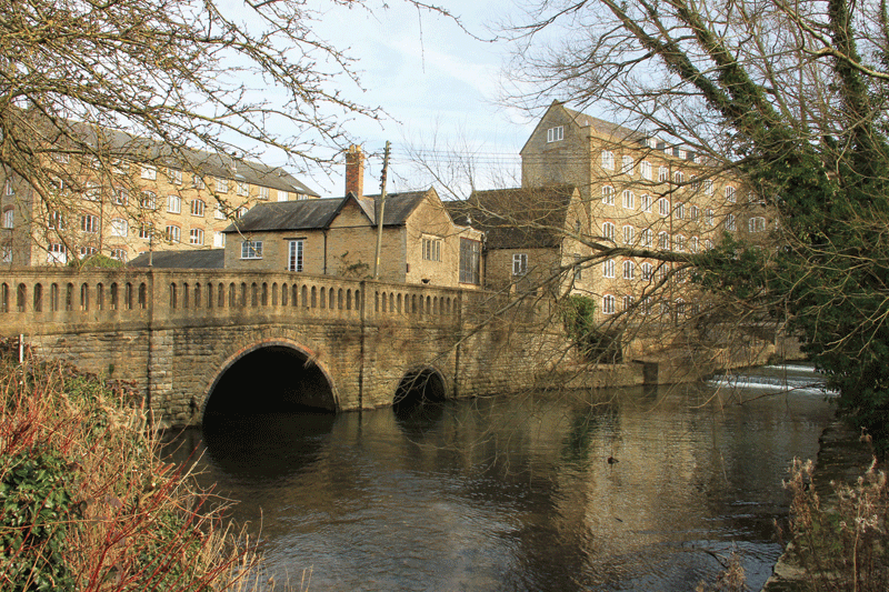
Above: Avon Mills
Turn left along Gloucester Street and left again by St Paul’s spire, to emerge by the 15th-century market cross at the top of the High Street. The gateway leading to the abbey, with a lock-up or ‘blind house’ on either side, is 18th-century, but the building next to it, now Rajah restaurant, was a 14th-century abbey guesthouse.
Head east along Oxford Street towards Tower House, which also dates from medieval times and is said to have been visited by both Henry VIII and Charles I. Its tower, which was built as an observatory, was added in 1834.
Turn left and follow the road as it curves down Holloway, passing the remains of the East Gate and running along a causeway at the bottom. Just before the bridge, turn right down steps to follow a footpath which may be muddy in places, but is well signposted.
After 225m, just before a stile, you pass the abutments of a bridge which carried the railway. Veer left across the next field, cross a footbridge at the end and turn right along a lane. As you cross Goose Bridge, look to the right to see Tower House silhouetted against the sky – and to appreciate how well defended the town must have been, with steep slopes encircled by the river and topped by high walls.
A little further on, after passing a flight of steps leading up Back Hill, the street widens to reveal an eclectic ranges of ancient buildings. The unassuming hall which lies through an archway on the left was the 14th century courthouse. At the end of St John Street, turn left to see a 12th-century arch of St John’s Hospital incorporated into 17th-century almshouses.
Across the river are Avon Mills, built in the 1790s by a clothier from Bradford on Avon who relocated here after his workforce rioted when he introduced new machinery. Cross into the memorial gardens and turn right along a path with the backs of houses in the High Street to your right, their gardens running down to the river.
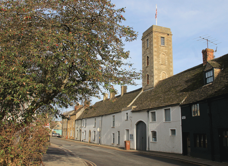
Above: Tower House
After passing a play area at the end, cross a bridge and head uphill. Turn right along King’s Wall, which after 40m leads past King’s House, one of Malmesbury’s grandest buildings, although, like so many of them, stripped of the render which once covered its rubble stone.
King’s Wall ends by the site of the South Gate. Turn left up the High Street and take the first right along Ingram Street. At the end, turn left along Silver Street which leads into Cross Hayes, once the site of the cattle market. At the far end is the Town Hall, where you will find the Athelstan Museum (entrance free), the tourist office and a cafe.
On the left-hand side of Cross Hayes was the George Inn, one of the largest in town, but now a veterinary hospital. An alleyway just beyond it leads to the High Street, where a right turn will take you past the market cross to the abbey.
Look out, as you tread the path to its entrance, for an unassuming gravestone on the right, recording, in faded lettering, the fate of Hannah Twynnoy, killed by a tiger from a travelling menagerie in 1703. And then, as you enter the porch, some of the most sublime Norman carving in the country confronts you in all its glory. There is much, too, to see inside this extraordinary building – not least the tomb of King Athelstan, the grandson of King Alfred, as well as a welcoming, dog-friendly cafe.
And from here it is but a short walk downhill back to the car park. Many more walks can be found in Andrew Swift’s Country Walks from Bath published by Akeman Press; akemanpress.com